Sunday, March 25, 2007

The Bahamas’ Sharks

The Bahamas and its Sharks

The country of the Bahamas stretches for some 500 miles to the southeast of Florida. Millions of tourists flock to this remote country in the Atlantic Ocean, yet its real population is only about 311,000 people. Although many people think that it is in the Caribbean, it is not. As you would think, the Bahamas’ main source of income is tourism because of the relaxing beaches and warm, tropical weather.

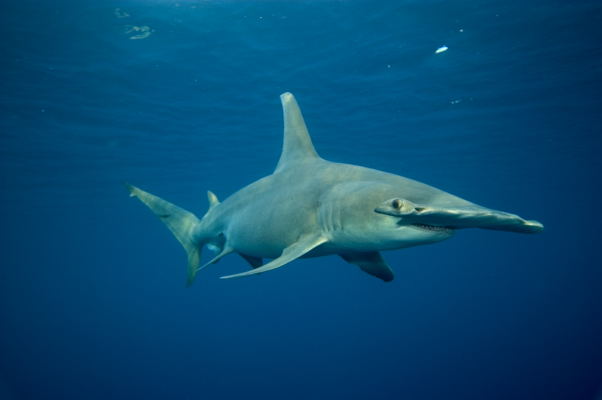
The most fascinating thing that I find about that country is its diverse shark population. More than 40 species of sharks roam throughout the country’s warm waters. The kinds of shark that you would find there include the Tiger, Hammerhead, Lemon and Blue sharks. For people to enjoy these magnificent creatures, the country of the Bahamas has established shark-seeing dives on numerous locations. This not only bolsters their economy, but it also gives people a good chance to look at sharks close up. If you went on one of these dives, you would find something new about sharks that would leave you dazed and open-mouthed for the rest of your visit.

This may sound like a haven for sharks, and it is. If I was a shark, and knew of that place, I would live there for the rest of my life. Even if I am not a shark, I probably would live there for the rest of my life anyway. Clear blue waters all around, peaceful and beautiful beaches, nearest factory at least 200 miles away; yeah, I think I can stay for a while longer.

Photos' sources: here and here

Friday, March 09, 2007

Iditarod Dogsled Race


The Iditarod is a 1,150 mile dog sled race beginning in Anchorage, Alaska and ending in Nome, Alaska. A musher and his sled is pulled by a team of about 15 dogs. The race which began last weekend continues with many of them at what appears about half way. The race originated from the serum(medicine) run in 1925 when Nome had an outbreak of diphtheria and the only way to get the needed medicine was by dogsled. At that time it was a relay team of dog sleds. (Remember the story of Balto?) The Iditarod is raced every year with the southern route this year being an odd year. You can see the standings and a lot of other interesting facts(such as the location of each musher, the number of dogs he still has racing, video clips, the weather conditions, map including an elevation map) at www.iditarod.com One of the reasons that the Iditarod is interesting to me is that my Dad's high school friend, Jon Korta, is racing in it this year. He is bib #24. This morning his standing is 36 out of about 66 remaining racers. It seems he is doing well considering it's his first year. They are required to take one 24 hour rest period and it appears he is doing just that.

Friday, March 02, 2007

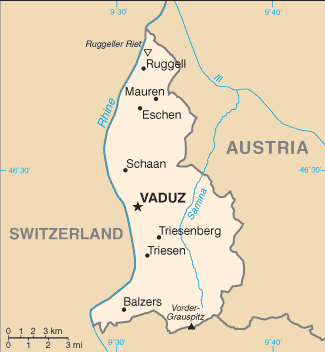
Invasion of Liechtenstein! (well not really)


Did you know that it is possible to accidentally invade Liechtenstein? Switzerland does. I didn't know until today but now I do.

Friday, February 23, 2007

Mongolia: A Barren and Strange Country

Mongolia: A Barren and Strange Country

Mongolia is literally a desert. The entire country is formed by the Gobi Desert, save a few mountains in the north. It is not near the sea so people cannot fish, and the land is unfertile so they cannot plant crops except in some places near the mountains.

So, instead of being farmers, most of the people of Mongolia are herders. They herd camels and they keep chickens. These people are constantly moving to find some good pastures. This makes Mongolia the least densely populated country in the world.

Mongolia is named after the Mongols, which was an army in the Ancient world that roamed across central Asia and Europe. At one point, the Mongols controlled an empire that stretched from Korea too Italy. No army has ever had so much land in its power ever since. The leader of this army was a man named Genghis Khan. When he died, his son Kublai Khan took over his kingdom.

Another interesting thing about Mongolia is that it is rich in dinosaur bones. Paleontologists from all over the world go there to find some new prehistoric creature. When the dinosaurs became extinct, the world was a little different. 65 million years ago Mongolia had a similar climate so the cold, dry environment preserved the bones very well.

Mongolia is a very primitive country. The people still live in yurts, which was the home of the Mongols, sort of like an Asian teepee. They are still nomads like their Mongol ancestors, but they are not warlike anymore. It is incredible how the lives of so many people can change so little through the centuries.

Friday, February 16, 2007

Malaysia

Malaysian Money

Malaysia is a very affluent nation and its main sources of income are petroleum, electronic goods and wood products. Before I elaborate any further on this most intriguing subject, I would like to make clear a few important points about this country. For instance, where is Malaysia? Malaysia is a country in Southeast Asia and it borders Indonesia, Thailand and small country called Brunei. Malaysia gained its independence from the United Kingdom on August 31, 1957.

Malaysia is a member of the Organization of Petroleum Exporting Countries, or OPEC. Many different countries from all around the world export oil, and OPEC ensures the regularity of the price, if the country is a member. This rule applies to Malaysia, since it is a well known member of OPEC. Two countries, who are not members and export oil, are Russia and Mexico.

Malaysia also exports electronic goods. A lot of our every-day devices, like phones and computers here in America, are made and manufactured in Malaysia. About 56% of all exports from Malaysia have to do with electronics. These, not only include computers and phones, but also include television sets, radio receivers, photography equipment, and electro-medical equipment, like X-rays, CAT scan projectors, etc.

Malaysians are experts in building techniques; hence the Petronas Towers in Kuala Lumpur, the capital of Malaysia. The Petronas Towers, opened in 1996, are the tallest office buildings in the world at 1,483 feet, surpassing the Sears Tower in Chicago. The man who designed the Petronas Towers was an Argentine-American named Cesar Pelli.

Another main source in Malaysia’s wealth is selling wood products. Fancy furniture, wood polishes, wood coatings and even wood floorings are exported every year. In many different woods too, such as teak, mahogany and soca, that all grow abundantly in the forests of Malaysia. The forests of Malaysia are being cut down to meet this demand, so their government is taking measures to preserve them. To state my point as clearly as possible, Malaysia is a very wealthy country indeed.

Tuesday, February 06, 2007

Map of Rio


Hello again. This a cartoon map of Rio, and to my surprise, it was amazingly accurate. It shows the Sugarloaf Mountain, the rock by the bay, and the beach where I went to.

Tuesday, January 23, 2007

More on Brazil


Hello Again,
Here is a photo of me and my brother at a mountain called Maria Comprida (Long Mary). You see why it's called Long Mary because it slopes down, on the side that I was on, therefore earning its name.

Sunday, January 21, 2007

Geo Game


I did a previous post ot Christmas Ideas. This is what I got!!


It's a game called Geo Derby. You race around a track answering questions. There is a map if you need it:)


I think it is really Great!!!

http://http://www.boardgamesexpress.com/prodinfo.asp?number=8104

I am back from Rio de Janeiro!


Hey guys. I just got back from some of the best six weeks of my life.
Above is a map of the state of Rio de Janeiro. I was in the city of Petropolis, also known as the Imperial City. This particular area of Brazil is very mountainous and has very curvy. Almost everyone got carsick on the way there and on the way back. We did go to the beach once, and it was pretty cool.

I will report on my trip again.

Tuesday, January 09, 2007

Independence Quiz Answers

Here are the answers to the Independence Quiz.

  1. Oman - 1650 (from Portugal)
  2. India - 1947 (from the United Kingdom)
  3. Romania - 1878 (from Turkey)
  4. Mauritius - 1968 (from the United Kingdom)
  5. Vatican City - 1929 (from Italy)
  6. Sweden - 1523 (from the Kalmar Union)
  7. Liechtenstein - 1719 (from the Holy Roman Empire)
  8. Norway - 1905 (from sweden)
  9. Czech Republic - 1993 (from Czechoslovakia)
  10. Iceland - 1944 (from Denmark)

Friday, January 05, 2007

Independence Quiz

Here's how it goes I'll give you a list of 10 diferent countries and then the year they became independent in (with a dash inbetween). You guess (in the comment box) who they became independent from.

  1. Oman - 1650
  2. India - 1947
  3. Romania - 1878
  4. Mauritius - 1968
  5. Vatican City - 1929
  6. Sweden - 1523
  7. Liechtenstein - 1719
  8. Norway - 1905
  9. Czech Republic - 1993
  10. Iceland - 1944

Thursday, December 21, 2006

Middle Eastern Empires

There is a really neat animated map of diferent empires near the middle east. It shows 5,000 years in 90 seconds.

hat-tip: The Lilting House

Monday, December 18, 2006

Tornadoes

I just found out (again from The Handy Geography Answer Book) that 90% of all tornadoes occur in the United States.

Wednesday, December 06, 2006

Christmas Ideas*


These are a few gift ideas for geo freaks.


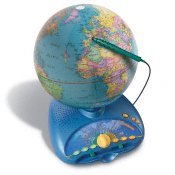
This is more of a family gift. It's expensive, but our family got one last year, and we use it all the time. Learn everything form the names of countries to the pronunciation of capital cities to other trivia. Two people can compete against one another in geography games. (My grandpa liked this one so much that he bought one of his own!)

Odyssey III Talking Globe ->

to view it click on the link below
http://www.leapfrog.com/Primary/GradeSchool/PRD_explorerglobe/Explorer+Globe.jsp?CID=KNC-CROSSQ4


World Discovery Deluxe Computer program ->

This program helps you locate places throughout the world. It has different kinds of quizzes at three different ability levels, so again, the whole family can enjoy it.

to view click the link below


http://www.smartkidssoftware.com/ndgws2.htm


We have a lot of geography games in the house, but the ones below are ones we play the most:


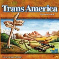
Trans America and Trans Europe ->


to view click the links below


http://www.fairplaygames.com/gamedisplay.asp?gameid=401&MP=1


http://www.fairplaygames.com/gamedisplay.asp?gameid=2826


Borderline card games ->


To view this and other versions click the link below


http://www.educationallearninggames.com/borderline-card-games.asp


(The links I've included should help you get more information on these items. I am in no way advertising for these sites, and haven't done any price comparisons or anything.)

* Please send some of you're favorite gift ideas so Mom knows what to get me!

Saturday, December 02, 2006

Gualdacanal

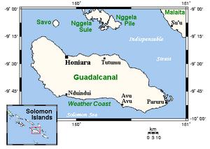
The Island of Guadalcanal: a place of beauty and violence

Even though just a small island in the Pacific ocean, Guadalcanal played a huge part in World War II. One of the bloodiest battles of all time was fought on the shores of this historic place. More than 2,000 American men were killed, while the Japanese buried ten times that amount. That many lives lost in only three days.

Even if it was a terrifying, not to mention deadly, area 60 years ago, Guadalcanal is now the most inhabited island in the Solomon Islands. With a normally tropical climate as well as beautiful beaches, it makes an excellent tourist destination. The country of the Solomon Islands lies about 200 miles off the coast of Papua New Guinea, another island country in the South Pacific.

Whereas 60 years ago there were ripped up planes falling from the sky every minute, ultra-intense combat everywhere, and the possibility that you might set off a land mine with any step you take, I think that one would rather enjoy being on the present-day island of Guadalcanal, one of the most lush and beautiful places in the world.

Tuesday, November 14, 2006

Geography Cup Scores

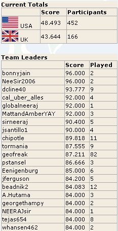
Here is the curent leaderboard on Geography Cup I'm at number 10 (I'm geofreak) and I played 82 times to get there.

Monday, November 13, 2006

Geography Cup


Yesterday a new geography quiz site started called the Geography Cup . I think that U.K. and U.S. challenged each other. In it there are 13 questions the first ten are countries you have
to find then the last three are geography type questions
e.g. what country is the biggest producer of coacoa (which by the way is Cote D'ivory). Have fun.

Friday, November 10, 2006

It's Coming Off

It's Coming Off

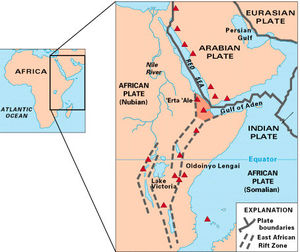
Encompassing many different countries in east Africa, and at a length of about 2000 miles, you have probably not heard of this spectacular land formation. I will not tell you the name, but I will give you clues in this paragraph, as I have given you two already. Ready… Go! Three lakes lie in it, Lake Victoria, Lake Tanganyika and Lake Malawi. One of the tallest mountains in the world lies on its' edge, Mt. Kilimanjaro. The worlds' longest river has its source in its area, the Nile River. Most of the Serengeti Plain lies within it. But perhaps the most important, concerning and amazing thing about it, is that it will cut the entire continent in two someday. Have you guessed it by now? If you have, good job, if you have not, it is the Great Rift Valley.

The valley does run through a great many countries, from Eritrea in the north, to Mozambique in the south, crossing ten other countries in between. The center of the valley covered with fertile plains, bordered by huge mountains and steep cliffs. I know that you have knowledge of the Serengeti Plain, and that most animals of Africa live there. Now as I said before, the Great Rift Valley will some day spilt Africa in half. The reason for that is because two of the Earth's plates are pulling apart from each other, or they're 'rifting,' creating a lowland or valley in between. At their current speed today, the plates should fully come apart in about 125 million years from now.

Diagram credits here.

Answers to "More True or False"

1. Twenty-seven U.S. states have land north of Canada's southernmost point. True.

2. The 4,724-mi Trans-Canada Highway is the world's longest national highway. True.

3. Canada has fewer lakes than any other country in the Northern Hemisphere. False. With almost a million, Canada has more lakes than any other country in the world.

4. Canada's border with the U.S. is 5,525 mi long. True.

5. Since Toronto has no direct access to the Atlantic, all goods from the city must be shipped overland. False. The St. Lawrence Seaway connects the Great Lakes to the Atlantic.

6. Canada has the longest coastline of any country. True.

7. Canada covers three time zones. False. There are six time zones in Canada.

8. The climate in British Columbia is the most severe in Canada. False. British Columbia has the most moderate climate of Canada's regions.

9. Canada has mountains named for Santa's reindeer--Dasher, Dancer, Prancer, Vixen, Comet, Cupid, Donner, and Blitzen. True.

10. Few people in Canada live near the U.S. border. False. Most of Canada's population live within a few hundred miles of the border.