Geography Cup Scores
 Here is the curent leaderboard on Geography Cup I'm at number 10 (I'm geofreak) and I played 82 times to get there.
Here is the curent leaderboard on Geography Cup I'm at number 10 (I'm geofreak) and I played 82 times to get there.
![]()
Yesterday a new geography quiz site started called the Geography Cup . I think that U.K. and U.S. challenged each other. In it there are 13 questions the first ten are countries you have
to find then the last three are geography type questions
e.g. what country is the biggest producer of coacoa (which by the way is Cote D'ivory). Have fun.
 It's Coming Off
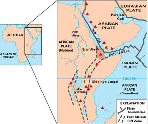
Encompassing many different countries in east Africa, and at a length of about 2000 miles, you have probably not heard of this spectacular land formation. I will not tell you the name, but I will give you clues in this paragraph, as I have given you two already. Ready… Go! Three lakes lie in it, Lake Victoria, Lake Tanganyika and Lake Malawi. One of the tallest mountains in the world lies on its' edge, Mt. Kilimanjaro. The worlds' longest river has its source in its area, the Nile River. Most of the Serengeti Plain lies within it. But perhaps the most important, concerning and amazing thing about it, is that it will cut the entire continent in two someday. Have you guessed it by now? If you have, good job, if you have not, it is the Great Rift Valley.
The valley does run through a great many countries, from Eritrea in the north, to Mozambique in the south, crossing ten other countries in between. The center of the valley covered with fertile plains, bordered by huge mountains and steep cliffs. I know that you have knowledge of the Serengeti Plain, and that most animals of Africa live there. Now as I said before, the Great Rift Valley will some day spilt Africa in half. The reason for that is because two of the Earth's plates are pulling apart from each other, or they're 'rifting,' creating a lowland or valley in between. At their current speed today, the plates should fully come apart in about 125 million years from now.
Diagram credits here.
1. Twenty-seven U.S. states have land north of Canada's southernmost point. True.
2. The 4,724-mi Trans-Canada Highway is the world's longest national highway. True.
3. Canada has fewer lakes than any other country in the Northern Hemisphere. False. With almost a million, Canada has more lakes than any other country in the world.
4. Canada's border with the U.S. is 5,525 mi long. True.
5. Since Toronto has no direct access to the Atlantic, all goods from the city must be shipped overland. False. The St. Lawrence Seaway connects the Great Lakes to the Atlantic.
6. Canada has the longest coastline of any country. True.
7. Canada covers three time zones. False. There are six time zones in Canada.
8. The climate in British Columbia is the most severe in Canada. False. British Columbia has the most moderate climate of Canada's regions.
9. Canada has mountains named for Santa's reindeer--Dasher, Dancer, Prancer, Vixen, Comet, Cupid, Donner, and Blitzen. True.
10. Few people in Canada live near the U.S. border. False. Most of Canada's population live within a few hundred miles of the border.
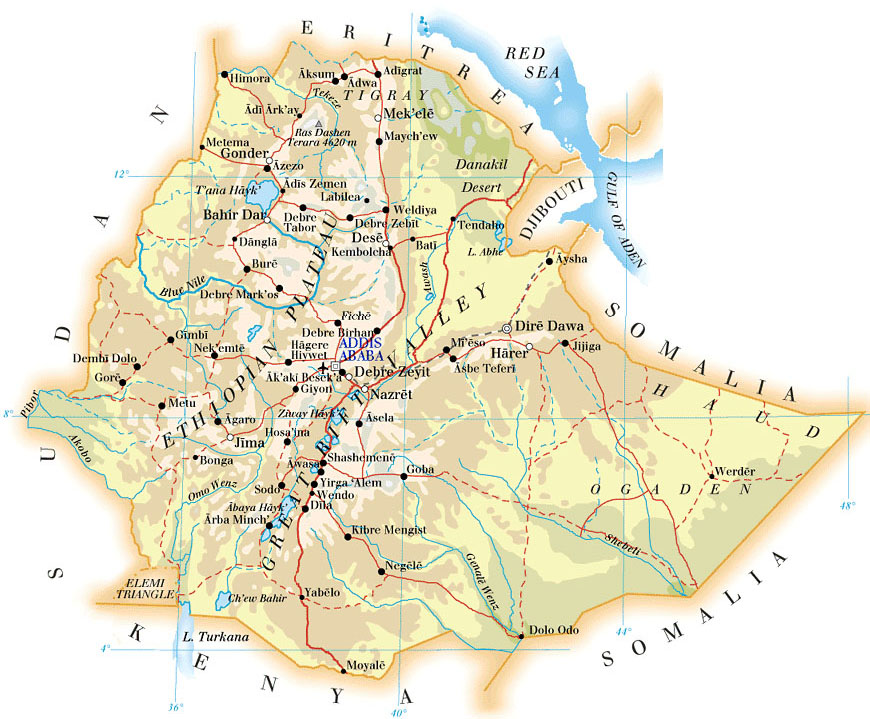 Last Saturday night, my family had some guests over for dinner. As you probably guessed from the title of this essay, their home country is Ethiopia. After they left, my mom told me that she had learned that since Ethiopia is such a mountainous country, their people are safe from most mosquito induced diseases, which are very common in that particular continent. A fact that I found to be very interesting is that eighty-percent of the mountains of Africa are located in Ethiopia.
I also think that it's very intriguing that Ethiopia is just barely landlocked by three countries; Eritrea, Djibouti, and Somalia. In the past, Ethiopia had a pretty funny name, Abyssinia. In World War II, Ethiopia was controlled by Italy, and the rest of Africa was controlled by the French, Spanish, British, German, and Portuguese. After the war however, the African modern nations started to form. One of these was Ethiopia, now a fully independent country.
